


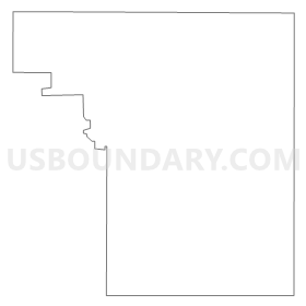
ELLSWORTH - T 1 Voting District, Pierce County, Wisconsin
About
Outline
Summary
| Unique Area Identifier | 696140 |
| Name | ELLSWORTH - T 1 Voting District |
| County | Pierce County |
| State | Wisconsin |
| Area (square miles) | 27.52 |
| Land Area (square miles) | 27.50 |
| Water Area (square miles) | 0.02 |
| % of Land Area | 99.94 |
| % of Water Area | 0.06 |
| Latitude of the Internal Point | 44.73701350 |
| Longtitude of the Internal Point | -92.42185020 |
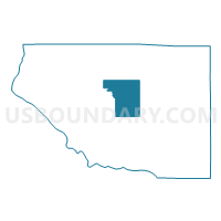
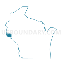
Maps

Graphs
Select a template below for downloading or customizing gragh for ELLSWORTH - T 1 Voting District, Pierce County, Wisconsin


Neighbors
Neighoring Voting District (by Name) Neighboring Voting District on the Map
- EL PASO - T 1 Voting District, Pierce County, WI
- ELLSWORTH - T 2 Voting District, Pierce County, WI
- Ellsworth - V 1 Voting District, Pierce County, WI
- Ellsworth - V 2 Voting District, Pierce County, WI
- Ellsworth - V 3 Voting District, Pierce County, WI
- GILMAN - T 1 Voting District, Pierce County, WI
- HARTLAND - T 1 Voting District, Pierce County, WI
- MARTELL - T 1 Voting District, Pierce County, WI
- MARTELL - T 2 Voting District, Pierce County, WI
- RIVER FALLS - T 1 Voting District, Pierce County, WI
- SALEM - T 1 Voting District, Pierce County, WI
- TRIMBELLE - T 1 Voting District, Pierce County, WI
Top 10 Neighboring County Subdivision (by Population) Neighboring County Subdivision on the Map
- Ellsworth village, Pierce County, WI (3,284)
- River Falls town, Pierce County, WI (2,271)
- Trimbelle town, Pierce County, WI (1,679)
- Martell town, Pierce County, WI (1,185)
- Ellsworth town, Pierce County, WI (1,146)
- Gilman town, Pierce County, WI (959)
- Hartland town, Pierce County, WI (827)
- El Paso town, Pierce County, WI (681)
- Salem town, Pierce County, WI (510)
Top 10 Neighboring Place (by Population) Neighboring Place on the Map
Top 10 Neighboring Unified School District (by Population) Neighboring Unified School District on the Map
Top 10 Neighboring State Legislative District Lower Chamber (by Population) Neighboring State Legislative District Lower Chamber on the Map
- Assembly District 29, WI (66,814)
- Assembly District 30, WI (66,575)
- Assembly District 91, WI (56,636)
Top 10 Neighboring State Legislative District Upper Chamber (by Population) Neighboring State Legislative District Upper Chamber on the Map
Top 10 Neighboring 111th Congressional District (by Population) Neighboring 111th Congressional District on the Map
Top 10 Neighboring Census Tract (by Population) Neighboring Census Tract on the Map
- Census Tract 9602, Pierce County, WI (5,996)
- Census Tract 9607, Pierce County, WI (4,874)
- Census Tract 9608, Pierce County, WI (3,698)